

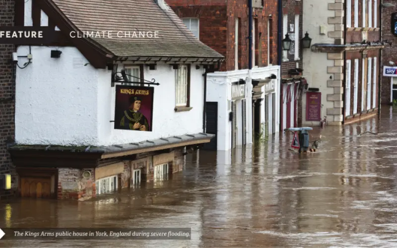


Flood and coastal erosion risk management (FCERM) in Aotearoa New Zealand is largely the responsibility of local government. While FCERM operates within the framework of national legislation and policy guidance that directs what and why, the choice of how and where it is delivered sits largely with regional councils and territorial authorities.
The UK has a more centralised approach in terms of funding, operational delivery and in the provision of support to local authorities.
Over the past 30 years, this approach has supported the development of national risk assessments, policy evaluation and strategic planning in ways that have not been possible in New Zealand.
As we take steps towards a national- scale flood risk assessment through the NIWA-led research programme Mā te haumaru ō nga puna wai ō Rākaihautū ka ora mo ake tonu: Increasing flood resilience across Aotearoa, it’s useful to reflect on the experience in the UK and what can be learned from it.
Coordinated and consistent
A centrally coordinated and consistent approach allows:
- work done at a local level to be easily stitched together to build a national picture
- work done at a national level to be designed to be used by local delivery teams in the same ways
- investments in technology, process, data and research at the centre to benefit all.
From the early 1990s, national initiatives have been undertaken to understand flood and coastal erosion risk, the cost and economic benefit of investing in risk management and understanding the impacts of climate change on the scale of loss. These have made a positive difference to funding available for FCERM and significantly influenced UK policy on climate change.
Insurance industry assesses coastal flood risk
The appetite to understand risk at a national level has created positive feedback between the methods and data used.
Increasingly sophisticated methods demand improved data, and improved quality and accuracy of data has enabled better methods.
This work has also not always been government-led. The insurance industry has also played a key role at times. Severe coastal flooding in North Wales in 1990 was the trigger event for the first National Coastal Flood Risk Assessment for England and Wales, commissioned by the Association of British Insurers (ABI).
The 1990 Towyn flood exposed a lack of knowledge of the location, ownership and condition of stopbanks. In response, the government’s National Rivers Authority initiated the National Sea Defence Survey, providing a comprehensive database of coastal stopbanks that detailed level of service, condition, structure, foreshore condition and areas protected.
Its availability enabled the ABI to commission its national risk assessment (1992–95), providing its members with information on the location and scale of coastal flood exposure.
The government was quick to see its value, reusing the ABI’s work initially to identify weak links in the stopbank system and then as the basis for national-scale benefit/cost work to make the case for increased investment from HM Treasury.
By 1999, not only were the coastal risk model outputs available digitally, but there were also nationally modelled fluvial flood extents, national property and land-use data, locally established level-of-service information for stopbanks and well-established depth and damage curves for different property types.
Wealth of data enabled national flood risk appraisal
This information was analysed to produce the National Appraisal of Assets at Risk from Flooding and Coastal Erosion. This provided national and regional estimates of annual average damages aggregated from calculations undertaken at an individual property level. Rerunning the analysis for different scenarios – for example, do nothing, maintain and improve defences – provided quantified evidence of the economic benefits provided by FCERM to the nation.
In 2000, the analysis was repeated to account for future climate scenarios by reducing defence standards in line with predicted regional changes in peak fluvial flows and relative sea-level rise.
Through the early 2000s, further improvements to methods and data were made.
Digital terrain model for flooding
A major insurer commissioned a national digital terrain model (DTM) at a 5 m² resolution to support its own flood modelling. This same DTM was used by the government’s Environment Agency to determine the extent of the 100, 200 and 1,000-year floodplains for regulatory and planning purposes.
The Environment Agency also established a national database of fluvial, tidal and coastal stopbanks and developed costings for the maintenance and replacement of typical flood defence structures.
It funded the development of probabilistic flood modelling methods that accounted for stopbank fragility and incorporated 2D flood spreading to produce national depth and probability assessments.
A risk receptor dataset was created that mapped out properties, major transport infrastructure, land use and other critical assets. This dataset was used for national risk assessment and also made available to local councils to support consistent local assessments.
Outcomes from database availability
This journey of well-directed methods and data improvement produced several notable outcomes.
Based on this work, in 2004, the government’s Chief Scientist commissioned a foresight study that looked at how different CO₂ emission scenarios and accompanying socio-economic policy settings would impact flood risk across England and Wales. This produced stark evidence of the potential for up to a 20-fold increase in annual average damages by 2080, illustrating the consequences and cost of unmitigated climate change.
Not only did this study help shape the UK’s policies on climate change and FCERM funding, it also had wider international influence through its promotion to world leaders during the UK’s 2005 presidencies of the EU and G7, and its results were referenced by the influential 2006 Stern Review on the Economics of Climate Change.
This risk model and economic analysis were used alongside the costing database to support further national benefit/cost assessments and to test out different funding scenarios, all informing comprehensive spending review processes run by HM Treasury.
This body of work supported a near trebling of central funding for FCERM from £240 million in 2001 to £700 million in 2012, and the approaches developed have been embedded into the tools used by the Environment Agency to develop further long-term investment strategies (2014 and 2019) that look at the needs for FCERM in the face of climate change.
By taking a national approach, the UK Government has clarity on the location and scale of flood and coastal erosion risk. Having nationally consistent models and datasets means that scenarios can rapidly be created to examine future climate impacts and test different interventions and investment policies. It demonstrates good science being applied at a national level to help policy development and impact significant funding decisions.
The situation here
Though the funding and delivery of FCERM in New Zealand is locally led, tools and data are being developed that will support a more nationally consistent approach to risk assessment. This should enable scenario development and the testing of policies and interventions as per the UK.
Finding ways to make these useful to local decision-makers and central policy-makers is the challenge that lies ahead. Learning from what has gone well in the UK should help us on that journey.