

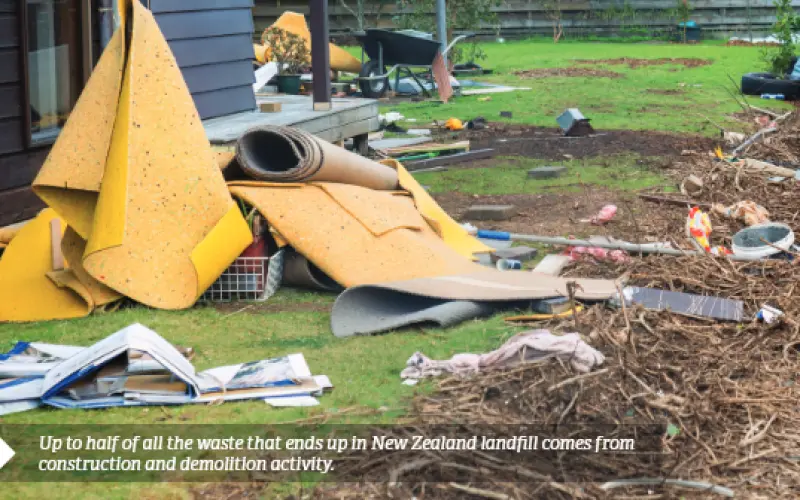


Construction is a dirty business. Up to half of all the waste that ends up in New Zealand landfill comes from construction and demolition activity, according to the Ministry for the Environment. Every home constructed produces an average of 4 tonnes of discarded timber, metal and plastics that’s destined for a one-way trip to the dump.
It’s not just a local problem. In an effort to clean up its act, the global construction sector has explored several strategies to reduce waste and move to more sustainable practices. One option that has enjoyed some success in other countries, including Australia and the UK, is transitioning to a circular economy.
Use and reuse
A circular economy is an economic model that minimises waste and maximises the use of reusable and recycled resources. Unlike the traditional linear economy, which follows a take, make, dispose pattern, a circular economy emphasises the continuous reuse of resources in a closed loop. In theory, it’s a game changer, but it has proven extremely difficult to take even the first steps, especially in an industry criticised for being as stuck in its ways as construction.
Several notable organisations, including Google, say the way to smooth and accelerate the transition lies with digital technology. The idea is that, by gathering and analysing data about materials, logistics and people, digital technology can help identify challenges, highlight areas of systemic waste and guide more informed decisions to better address the issues holding things back. From this work, four transition technologies have emerged – asset tagging, geospatial data, complex data analysis and connectivity.
Asset tagging
Asset tagging provides information about the condition and availability of products,components and materials. Access to this information can extend the lifespan of an asset, enable additional use cycles and contribute to resource recovery at the end of its life.
In construction, it often involves placing a unique RFID tag or QR code on each asset. These link the asset to a database that can tell you exactly what the asset is, where it came from, who sent it, when it arrived, what it’s for, where it’s supposed to be used, how to handle it safely and a myriad of other useful information.
‘Basic asset tagging solves a hugely problematic issue on many sites – how to track materials,’ says Professor Robert Amor from the School of Computer Science at the University of Auckland. ‘It can be very difficult to check quantities by hand. The manufacturer tagging each asset with an RFID or barcode means it’s possible to scan assets as they arrive, automating the process and making it much faster and more accurate.’
In a circular economy, it’s useful to know this information over the full history of the asset. For instance, if a beam in a building is a candidate for reuse, what happened to it over its lifetime? Was it properly maintained? Has it been through a fire or seismic event? In theory, asset tags can provide this information.
Ideally, you could stand outside a building, wave a scanner across it and all the assets would pop up in a big database.
‘Unfortunately, even the most advanced tagging technology still falls well short,’ says Professor Amor.
Passive RFID, which operates without a power source, is a relatively close-proximity technology, with an effective range of no more than a few centimetres. Active RFID systems solve this problem, but the tags are expensive and batteries inevitably run flat, making it unsuitable for the multi-decade life cycle of a built asset.
Geospatial information
By itself, geospatial information is essentially location data, but when combined with asset tagging, it provides the ability to track assets, materials, components, products and people. Depending on how the geodata is collected, it can track assets around a construction site or across the world.
In a circular economy, it’s particularly useful for linking BIM models together in a geographic information system (GIS). Although they can be highly detailed 3D or 4D representations, BIM models are often isolated, only considering the construction site and buildings and the immediate surroundings. On the other hand, many GIS systems lack detail of buildings at all, even at the urban or city level.
‘As we think in a bigger picture about how we use and reuse our cityscapes and urban areas, it’s much more important that we bring these systems together,’ says Professor Amor.
He believes connecting the two would greatly improve planning outcomes as they enable much more detailed simulations and high-accuracy analysis of the impacts on land use and our urban environments.
‘Take seismic planning, for example. Imagine that, from within a nationwide GIS system, you could drill down to street level in any city and inspect each building, look at its age, construction materials, foundations, ground types and so on. All that information already exists, we just can’t get to it in ways that make it useful.’
Complex data analysis
Complex data analysis or big data refers to number crunching on a scale beyond what’s possible with traditional computer systems. With advanced, cloud-based processing power, computers can now analyse vast datasets in real time, allowing for faster, more informed decisions and better deployment of resources in built assets.
One of the most anticipated uses for big data in construction is the ability to link the physical and digital worlds together – the so-called digital twin. A digital twin is a complete representation of a building (or other asset) in software. It’s possible to simulate events – everything from a traffic jam to a major earthquake – and see how the model responds. The more detailed the model and sophisticated the simulation, the more likely the simulated outcomes will match what would happen in the real world.
‘That’s where big data will most impact construction. The ability to make better real-world decisions via information you gained in the digital world is an enormous step forward. It benefits almost everything in a circular economy, from waste minimisation to resource allocation. It’s just a better, more granular understanding of what’s happening in real time in our buildings and cities,’ says Professor Amor.
Connectivity
The trick, however, lies in the data – accessing vast quantities of the stuff in real time. Some buildings already have high-quality data feeds, but again, it’s often used in isolation and not shared as widely as it could be.
‘If the data’s siloed, the decisions are siloed too. We’re not making global decisions, which would optimise how we run our construction projects to make better towns and cities, help people move around and limit waste and pollution. And that’s because we lack a way to bring all that data together.’
Unfortunately, there are few standards when it comes to data. One organisation will use a completely different dataset and software system to the next. As a result, data often isn’t shared, and when it is shared, it is often of limited interoperability simply because the data isn’t in the right format, it lacks quality or not enough was collected.
‘Until we can figure out how to all use good data and good data formats that everyone understands, connecting together and sharing information in a useful way is going to be very difficult,’ says Professor Amor.
‘It’s really hard to take the next steps toward a circular economy and do better because the data doesn’t support us doing better.’